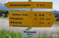
- Sign

Tour in alpine terrain
Please check the following points:
TOUR DESTINATION
It should be asked in advance whether the tour destination is generally accessible.
walking distance | technical difficulties | requirements for walkers |
|---|---|---|
trail |
| no mountain experience and equipment necessary |
medium difficult |
|
|
difficult trail (black) |
|
|
HELP WITH PLANING
Topographic maps, tour guides, descriptions as well as the informations of experts helps planning your tour.
Maps:
You get Maps of Austria of the Bundesamts für Eich- und Vermessungswesen (BEV) on the scale of 1: 50 000 (ÖK50) or from the Alpenverein (AV) for the most important mountain regions of Austria on the scale of 1:25 000.
For tour planning you need some benchmarks: Per hour a group walks 4000 meters, 300 height meters and 500 height meters downhill.
LINKS FOR TOUR PLANING
EQUIPMENT
You need some clothes you can wear one above the other. Don't forget the raincover and mountain boots. For emergency you should have a small first aid package, a mobile phone and a flashlight.
WEATHER PLANING
You have always check the wather forecast.
weather forecast | |
telephone information desk | Personal advice: +43-512 291600 |
weather forecast of the Alps: 0900 91 1566 80 | |
East Alps: 0900 91 1566 82 | |
regional weather: 0900 91 1566 81 |
ALPINE EMERGENCY
Alpine emergency: 140
Euro emergency: 112
